A Wideroe de Havilland Dash 8-100, registration LN-WIP performing flight WF-834 from Bodo to Svolvaer (Norway), had been holding at FL090 about 13nm southsouthwest of Svolvaer before commencing the straight in approach to Svolvaer's runway 01 in instrument meteorological and night time conditions. While descending through about 1000 feet indicated altitude the crew received a GPWS warning and initiated a go around. The crew subsequently decided to return to Bodo where the aircraft landed safely.
At the time the barometric pressure QNH was 987 hPa causing the transponder altimeter, which always indicates according to QNH 1013.25 hPa, to indicate 1000 feet, when the aircraft however was 774 feet lower and just about 226 feet AGL over the water surface about 3nm before the runway threshold.
Norway's Havarikommisjonen (AIBN) rated the occurrence a serious incident and opened an investigation stating the crew received a "Pull Up!" GPWS warning, went around and returned to Bodo. They were flying about 700 feet lower than their indicated altitude and 700 feet lower than they thought due to an uncorrected altimeter.
Norwegian Media reference a different flight performed on Oct 12th 2022 by LN-WIA in their links.
On Sep 26th 2025 the AIBN released their final report concluding the probable causes of the serious incident were:
The flight from Bodø to Svolvær was planned with marginal weather conditions in Svolvær. En route, the crew were informed that snow had to be cleared from the runway at Svolvær Airport Helle and that they were cleared to a holding pattern. They started their approach after spending approx. 10 minutes in the holding pattern around the reporting point OSRUL. The crew had forgotten to set the local QNH for the approach and was therefore 700 ft (213 m) below the indicated altitude. When the aircraft was 3.1 NM from the runway threshold, EGPWS calculated the aircrafts geometric altitude to be below the Runway Field Clearance Floor (RFCF) vertical profile and gave an aural Too Low terrain alert. The crew immediately aborted their approach and returned the Bodø, where they landed.
The checklists and procedures used by Widerøe to set correct QNH before landing were thought of as individual barriers. The investigation has shown that the checklists and procedures had some dependencies making them less efficient barriers.
The investigation has shown that there is no single technical system in use in Norwegian airspace that is capable of detecting deviations between reported QNH and the airplanes QNH, and that human barriers alone are not enough to guarantee that local QNH is set. There are ways of displaying an aircraft QNH as part of Surveillance (SUR), provided that Avinor Air Navigation Services (ANS) Norwegian Air Traffic Control System (NATCON) is used as the Air Traffic Management (ATM) system. The air traffic services performed the duties of Aerodrome Flight Information Service (AFIS) at Svolvær airport Helle. There are currently no procedures in place for this service to be provided by AFIS.
The airplane, LN-WIP, was fitted with a transponder unable to send QNH values. The air traffic services were therefore not able to read QNH.
Based on this investigation the NSIA is of the opinion that an independent system for monitoring aircraft pressure setting, with operational procedures, will increase aviation safety. Avinor ANS has equipped several air traffic control units and flight information units with a monitoring system called SUR. SUR is considered a supporting tool for AFIS and does not change the service provided even where new systems have been introduced.
This incident with LN-WIP occurred due to a combination of technical weaknesses and deficiencies and operational, human and organisational factors.
Widerøe has introduced several measures to help strengthen focus on CRM and workload management for commander training and line checks. As a result, the NSIA does not issue any safety recommendation regarding this.
The NSIA issues a safety recommendation to the Norwegian CAA to assess the risk posed by incorrectly set QNH and to implement risk-reducing measures. A safety recommendation is issued to Widerøe recommending that the company upgrade the transponders on their aircraft to enable them to transmit pressure settings and thus be part of a system for monitoring aircraft pressure settings (QNH) in Norwegian airspace. A safety recommendation is also issued for Widerøe to review its checklists and procedures for verification of QNH.
Metars:
ENSH 222050Z 30009KT 240V340 1000 SHSN VV007 00/M02 Q0987 RMK WIND 150FT 26013G24KT=
ENSH 222020Z VRB01KT 2000 SHSN VV010 M00/M00 Q0987 RMK WIND 150FT /////KT=
ENSH 221950Z 34005KT 260V010 1500 SHSN VV005 M00/M00 Q0987 RMK WIND 150FT 34006G45KT 290V060=
ENSH 221920Z 36004KT 310V060 1300 SHSN VV006 M00/M01 Q0987 RMK WIND 150FT 30004KT 230V360=
ENSH 221850Z 31007KT 260V010 2000 SHSN VV006 00/M01 Q0987 RMK WIND 150FT 30010G20KT 210V350=
ENSH 221820Z VRB04KT 4000 -SHSNRA VV008 M00/M01 Q0987 RMK WIND 150FT 29011G23KT 260V360=
ENSH 221750Z 24006KT 210V280 3000 -SHSN VV013 00/M02 Q0988 RMK WIND 150FT 24008KT 220V280=
ENSH 221720Z 20009KT 170V240 9999 -SHSN FEW008 BKN018 00/M02 Q0988 RMK WIND 150FT 26010G26KT 200V340=
ENSH 221650Z VRB01KT 5000 -SHSN VV012 M00/M01 Q0988 RMK WIND 150FT 29012G23KT 230V340=
ENSH 221620Z 21005KT 4000 -SHSN VV008 M00/M01 Q0988 RMK WIND 150FT VRB02KT=
Map and flight trajectory (Graphics: AVH/Google Earth):
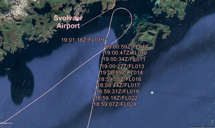
This article is published under license. Article Source
Published Date